Close
Close
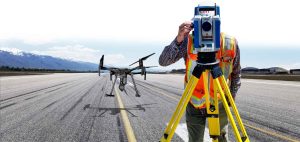
UAV Surveying & Drone Mapping Services
Need precise data faster than traditional ground surveys? Our UAV surveying services deliver high‑resolution 3D maps, topographic models, and actionable insights for projects.
-
Why Choose Drone Surveying?
WHY CHOOSE DRONE SURVEYING?
Moreover, drone technology lets you capture more detail in less time while cutting field costs up to 70 percent.
- Faster data collection—cover up to 1,000 acres per flight
- Safely map hard‑to‑reach areas such as wetlands, mountains, and active roadways
- Achieve centimeter‑level accuracy with RTK/PPK positioning
- Reduce site revisits thanks to rich, repeatable datasets
-
Highly accurate, detailed 3D map
HIGHLY ACCURATE, DETAILED 3D MAP
Our surveys are done with specialized laser equipment and provides a highly accurate, detailed 3D map that shows:
- Roadway
- Barriers
- Overhead wires
- Waterways
You can be sure that CMT Technical Services is able to provide you all the accurate survey data you need for your project. There are a couple of things that make drone surveying special. Esri UAS Mapping & Data Integration
- It is faster than traditional land surveying
- Capability to map land that is not easily accessible such as wetlands, mountains, and deserts
-
UAV Surveying Services Capabilities
UAV SURVEYING SERVICES CAPABILITIES
What can you capture with drone surveying? A few things include:
In addition, our FAA‑licensed pilots use photogrammetry‑grade sensors and LiDAR to provide:
- Land & boundary surveys
- 3‑Dimensional mapping & digital terrain models (DTMs)
- Orthomosaic imagery & aerial photography
- Pavement distress & crack analysis
- Stockpile volume calculations
- Slope stability & earth‑work monitoring
Where do we do drone surveys?
A drone survey would be a great tool for Arizona desert areas or Idaho mountainous terrain. In Texas, Colorado, or Utah, it can survey quicker than a traditional survey.
No matter what the terrain in your state, a drone survey can quickly survey, 3D map, and provide other data for your project.
Surveying from the air can provide big benefits.
Other benefits include:
- Drone surveying
- 3-Dimensional mapping
- Aerial videos and photography
- Stockpile quantity determination
- Pavement distress mapping
CMT Technical Services can provide your project drone surveying for any areas that may be a problem for traditional surveying.
-
Deliverables You Receive
DELIVERALBES YOU RECIEVE
Colorized point cloud of industrial facility produced by drone mapping
- Geo‑referenced orthomosaics (TIFF/JPEG)
- Point clouds (LAS/LAZ)
- Contours & break‑lines (DWG/DXF)
- Cut/Fill reports & quantity take‑offs
- Web‑based 3D viewers for quick stakeholder review
-
UAV Surveying Services in the Mountain West
UAV SURVEYING SERVICES IN THE MOUNTAIN WEST
Based in Utah, we mobilize rapidly to Utah, Idaho, Arizona, Colorado, and Texas job sites.
-
Start Your UAV Survey Today
Start Your UAV Surveying & Drone Mapping Services Today
Ready to see your site from a higher vantage? Request a Quote or call 1‑833‑620‑2688 to schedule an expert‑led drone survey.
Explore other ways we can help on our Surveying Services page.